Imagine Flying into the World’s Most Hazardous Airport
Welcome to Nepal’s Lukla’s Tenzing Hillary Airport (LUA)
Risks Associated with Aircraft Taking Off and Landings
A dangerous airport is perhaps best defined as a combination of challenging geographical, meteorological, and infrastructural factors that greatly add to the risks associated with an aircraft landing. These risk factors often result in accidents and can make routine flight operations difficult, even for the most experienced aviators.
The Gateway to Mount Everest
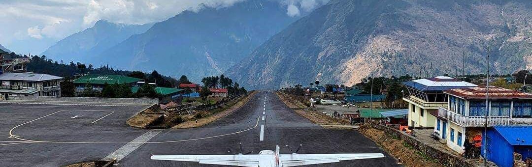
Geographical Challenges: One key indicator that an airport is dangerous is its proximity to difficult terrain. This includes airports perched high in mountainous regions, where approaches and departures demand complex navigation procedures through narrow valleys and between high and uneven peaks. One example is Lukla Airport in Nepal. This airfield, known as the gateway to Mount Everest, has a surprisingly short runway with an abrupt drop-off at one end and a shear mountain face at the other, leaving little to no room for poor judgment or errors.
Powerful High-Intensity Crosswinds
Meteorological Conditions: Extreme and highly unpredictable severe weather conditions substantially increase an airport’s danger quotient. Airports situated in regions prone to heavy, thick fog, gale-force winds, sudden storm development, or icy conditions pose clear aviation risks. For example, Madeira Airport in Portugal is well-known for its powerful, high-intensity crosswinds, which can make landing particularly challenging and dangerous.
Runways With Significant Gradients
Runway Characteristics: Short, limited-distance runways, or those with non-standard configurations, largely increase the difficulties of conducting safe flight operations. A short runway means a much smaller error margin during takeoff and landing. Additionally, runways with significant gradients, slopes, or uneven surfaces typically complicate flight approach and landing phases. The runway at Courchevel Altiport in France is notorious for its steep and uneven gradient, which demands precise pilot control throughout the landing.
Inadequate Infrastructure
Infrastructural Limitations: Lack of proper and adequate airport infrastructure also contributes to overall danger levels. This includes limited or poorly performing navigation aids, inconsistent or dim lighting, and insufficient safety or protective areas in the immediate runway zone. Airports in remote locations, not surprisingly, lack the modern and latest navigational aids available at larger, more modern commercial airport facilities. Inadequate infrastructure, as expected, requires exceptional skill and vigilance from pilots operating to and from these airports to ensure maximum safety.
Far Too Many Airplane Accidents Over the Years
As mentioned above, Lukla’s Tenzing Hillary Airport (LUA) in Nepal is known by many pilots within aviation circles as a rather treacherous airport to navigate, especially at night. The airport has historically been the epicenter of far too many airplane accidents, many of which have sadly resulted in substantial loss of life. There are even reports of some pilots refusing to fly to this airport due to its high-risk factors.
The Nepalese Capital City of Kathmandu
Perhaps one of the most notable things about the airport and its sister airport, Tribhuvan International Airport (KTM), which is just 30 minutes away, is that they serve as staging points for those intent on trekking to the top of Mount Everest. While Lukla’s Tenzing Hillary Airport (LUA) has an elevation of 4,390 feet, Tribhuvan International Airport (KTM) sits at a staggering 9,337 feet above sea level. This high-elevation airport serves the Nepalese capital city of Kathmandu.
The First Two Climbers to Successfully Summit Everest
With several hundred people a year attempting to climb Everest each season and that number increasing, the demand for scheduled flights to and from Kathmandu will only continue to grow. With great respect, Lukla’s Tenzing Hillary Airport (LUA) is named in honor of Sherpa Tenzing Norgay and Sir Edmund Hillary, the first two climbers to successfully summit Everest. Whether making it safely to the airport or scaling the rugged ridges of Everest, the entire area is brimming with challenges and immense risks.
Fierce Wind Shear
Mostly 7,000-meter-high peaks flank Lukla’s Tenzing Hillary Airport (LUA). These include Kusum Kanguru, topping out at 6,367 meters, and Numbur, with a towering peak of 6,959 meters. The localized climate within the valley is known to generate fierce wind shear, making it a highly technical airport for just about any daring commercial airliner. Also, less dense air at higher altitude airports diminishes engine thrust output. In addition, reduced air resistance makes it more difficult to slow down upon landing, which translates into needing more runway.
12% Uphill Runway Gradient
That said, Lukla’s runway is shorter than most other runways. The runway is aligned with magnetic North as RW 06 and RW 24, or 60 degrees and 240 degrees on the compass. The runway is old and shows its age with occasional asphalt patches. It rests upon a narrow mountain shelf and offers a mere 1,729 feet of usable landing surface. Add a 12% uphill runway gradient to this already sketchy situation, and you have a big challenge for even the best-trained and most experienced pilot. Although the inclined runway surface does assist in slowing aircraft more effectively after landing,
Published Go-Around Procedures
Anyone familiar with normal airport operations will know that runways at most airports will have published go-around procedures. However, at Lukla Airport, there is no such luxury. Because of the massive mountains in all quadrants, there is no option to go around. In other words, pilots are committed to landing once the final approach has commenced. And since there are no radar or navigation aids at the airport, pilots become fully dependent upon what they can see visually or through their instruments.
Sudden Erratic Weather Conditions
Equally alarming is that nearly one-half of all flights over the course of a year are canceled for one reason or another. The Himalayan mountains and the entire region are known for unpredictable and sudden erratic weather conditions. Many factors can contribute to the airport authorities deciding to temporarily close the airport until conditions improve, from extreme crosswinds to heavy downpours during Monsoon season and low visibility.
Mission-Capable Helicopters
Finally, not all airplane types or rotorcraft can safely operate to and from Lukla. Larger commercial jets cannot operate on such a limited-length runway at a high elevation. Typical aircraft flying to and departing from Lukla include Pilatus PC-6 Porters, De Havilland DHC-6 Twin Otter, L-410 Turbojet, and Dornier Do-228. Certain mission-capable helicopters can also operate safely at this extreme airport.
What Pilots Can Do to Improve Safety
Pilots must maintain an acute awareness of their surroundings when operating in and out of a hazardous or special airport. Situational awareness is perhaps the core of any safe approach, departure, landing, or takeoff at these airports. Frequent flight simulator exercises and other flight safety training help to keep pilots at the top of their game when navigating complex and dangerous airports. When all risk factors are considered, and safety protocol is followed, dangerous airports become safer and easier to manage.